1/3


GPS Distance(Yards and Meters) for Golf
1K+التنزيلات
3.5MBالحجم
1.0(08-07-2020)الإصدار الأخير
التفاصيلالمراجعاتالنُّسَخالمعلومات
1/3

وصف لـGPS Distance(Yards and Meters) for Golf
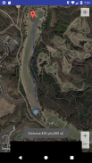
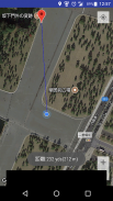
"Gps Distance" is used to measure distance between current geopoint to tapped geopoint.
How to use:
- Only tap the map. Application shows distance between two points.(yards/meters)
-If your current position is not displayed correctly, press and hold to set the current position. (A blue marker will be displayed.)
Use Case:
-Golf, Hiking,Horse riding, Climbing, Shooting every outdoor sports.
GPS Distance(Yards and Meters) for Golf - معلومات APK
نُسخة APK: 1.0الحزمة: jp.co.mob.nishimura.gpsdistanceالاسم: GPS Distance(Yards and Meters) for Golfالحجم: 3.5 MBالتنزيلات: 1الإصدار : 1.0تاريخ الإصدار: 2020-07-08 20:04:49الشاشة: SMALLيدعم CPU نوع:
عنوان الحزمة: jp.co.mob.nishimura.gpsdistanceتوقيع SHA1: 81:A1:EF:21:2A:C3:3D:E5:9D:9C:01:D7:E2:03:35:96:51:15:60:5Cالمطور (CN): Androidالمنظمة (O): Google Inc.محلي (L): Mountain Viewالبلد (C): USولاية/مدينة (ST): Californiaعنوان الحزمة: jp.co.mob.nishimura.gpsdistanceتوقيع SHA1: 81:A1:EF:21:2A:C3:3D:E5:9D:9C:01:D7:E2:03:35:96:51:15:60:5Cالمطور (CN): Androidالمنظمة (O): Google Inc.محلي (L): Mountain Viewالبلد (C): USولاية/مدينة (ST): California
آخر إصدار من GPS Distance(Yards and Meters) for Golf
1.0
8/7/20201 التنزيلات3.5 MB الحجم


